Ice structure discovered at position 69°48’00.0″S 32°15’36.0″E on Roi Baudoin Ice Shelf, Princess Ragnhild Coast, Queen Maud Land, East Antarctica is not connected to 2004 superbolide
UPDATE (17 February 2015)
The giant circular scar on the King Baudouin Ice Shelf: a glaciologist’s perspective
Interview with Dr. Jan Lenaerts (17 February 2015)
Taking a second look at the circular scar on the King Baudoin Ice Shelf
Interview with Graeme Eagles
(20 January 2015)
First published 8 January 2015, 21:04 CET, UPDATED 19 January 2015
Is the newly discovered structure on the Roi Baudoin Ice Shelf (Princess Ragnhild Coast, Queen Maud Land, East Antarctica) really an impact crater or rather an ice doline, as proposed by Doug MacAyeal from the University of Chicago?
The analyses of the acquired Polar 6 measurements at the Alfred-Wegener-Institut will not start until the beginning of February and might take several months.
What caused the ring structure? On exploration …
by Dr. Olaf Eisen (19 January 2015)
There is apparently no connection to the Antarctic superbolide of 3rd September 2004.
The size of the structure (~ 3 km) does speak against it being the result of a meteorite impact in connection to the superbolide of 3 September 2004 as well.
Furthermore, the structure can be seen on images of the region from the 1990s. This animation by Allen Pope shows how the position of the structure has moved with the ice since the 1990s.
video MP4 (please play as loop)
“On December 20th, while on mission aboard AWI’s Polar 6 aircraft over the Princess Ragnhild Coast, geophysicist Christian Müller from Fielax (a company supporting the survey), looked out of the window of the aircraft and spotted an unusual formation in the ice over the King Baudoin Ice Shelf.”

Aerial photo of the crater site, taken with the Polar 6 board camera, while the aircraft was flying 7000 feet above the ice shelf. Photo: Alfred-Wegener-Institut

Photo of the possible meteorite impact zone taken from AWI’s Polar 6 aircraft during an aerial survey – © Tobias Binder, AWI
A serendipitous find during an airborne geophysical survey
Press release (8 January 2015) Princess Elisabeth Antarctica Station
video interview with Graeme Eagles and Christian Müller
“In this video, you see footage of Christian Müller, along with AWI survey team leader Graeme Eagles, describe what they found on the ice shelf.”
The picture below shows an overlay of an image of the Antarctic Princess Ragnhild coast line (1999) with a NASA Aqua satellite image (3 September 2004) showing the meteor dust trail (shadows and scattered sunlight) above sea ice one hour after meteoroid’s disintegration.
The meteoroid entry was first detected at an altitude of 75 km; at 12:07:20.975 UTC; 67.72°S, 16.89°E (left yellow marker in picture) and the disintegration of the meteoroid happened at 32 km (67.688 S, 18.008 E) and 25 km altitude (67.678 S, 18.178 E), see other yellow markers. The intersection of the projected path with the Earth (red marker) was at 67.64°S, 18.83° E, according to Klekociuk et al (2005)
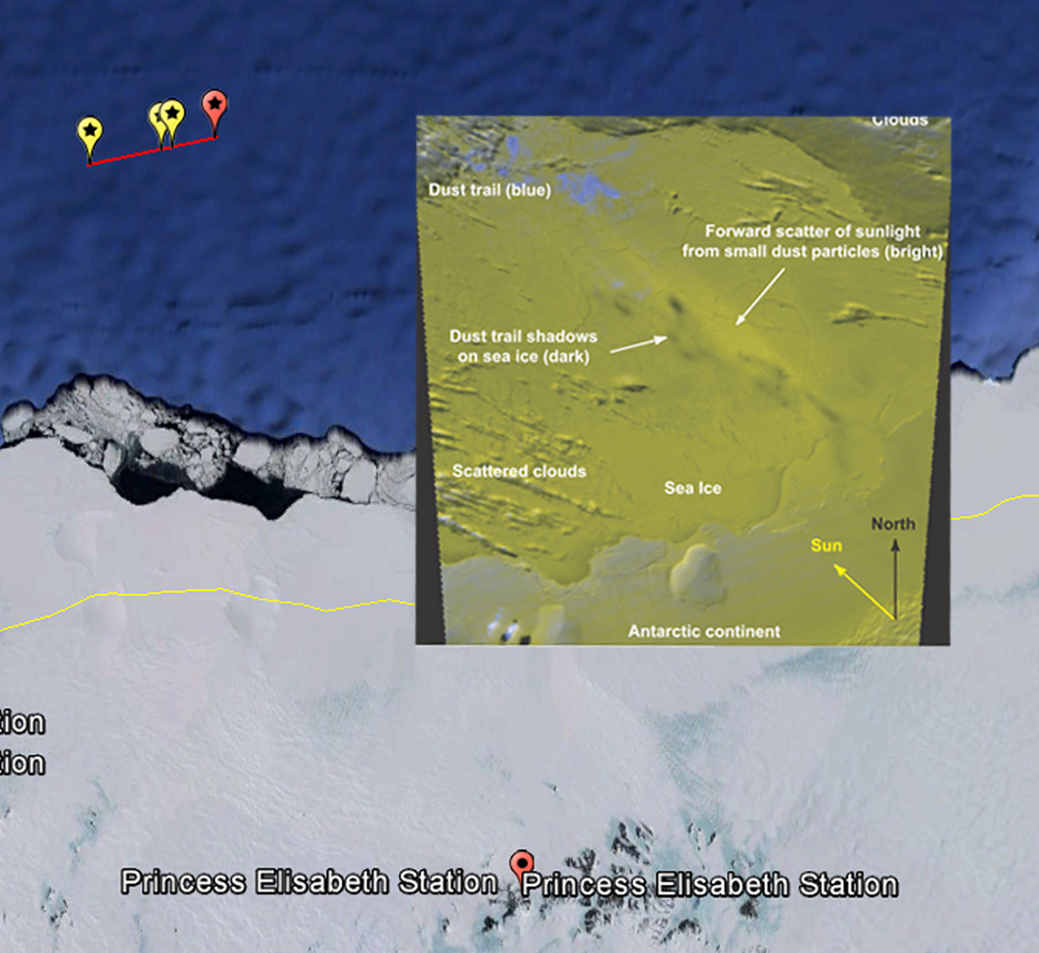
Aqua satellite image photo credit: A. Klekociuk, AAD; NASA
atmospheric trajectory and heliocentric orbit parameters for the 03 Sep 2004 fireball (DOC)
Global Detection of Infrasonic Signals from Three Large Bolides (2007)
Cosmic hole-in-one: capturing dust (AUSTRALIAN ANTARCTIC MAGAZINE, PAGE 7, ISSUE 8 AUTUMN 2005 (PDF)